Air Traffic Management
IXO SYSTEM
IXO SYSTEM is an information system and a platform for gathering, processing and distributing aeronautical data received from a variety of data sources. It is developed in close collaboration with aviation authorities, ANSP experts, and domain specialists.
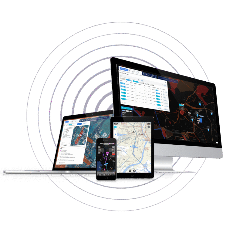
IXO consists of multiple web and mobile applications that allow working with specific data in a customizable environment.
About IXO SYSTEM
Description
IXO SYSTEM is a state-of-the-art information system and technological platform designed for collecting, processing, and distributing aeronautical data from a variety of sources. It is developed in close cooperation with aviation authorities, air navigation service providers (ANSPs), and domain experts.
The system includes a suite of web and mobile applications that enable users to work with specific data in a customizable environment. From pilots to ANSP personnel, users can efficiently manage flights, conduct pre-flight briefings, and ensure compliance with ICAO standards and regulations.
Benefits
All in one airspace management
Safety risk mitigation
Full situational awareness
Open architecture
Advanced cybersecurity
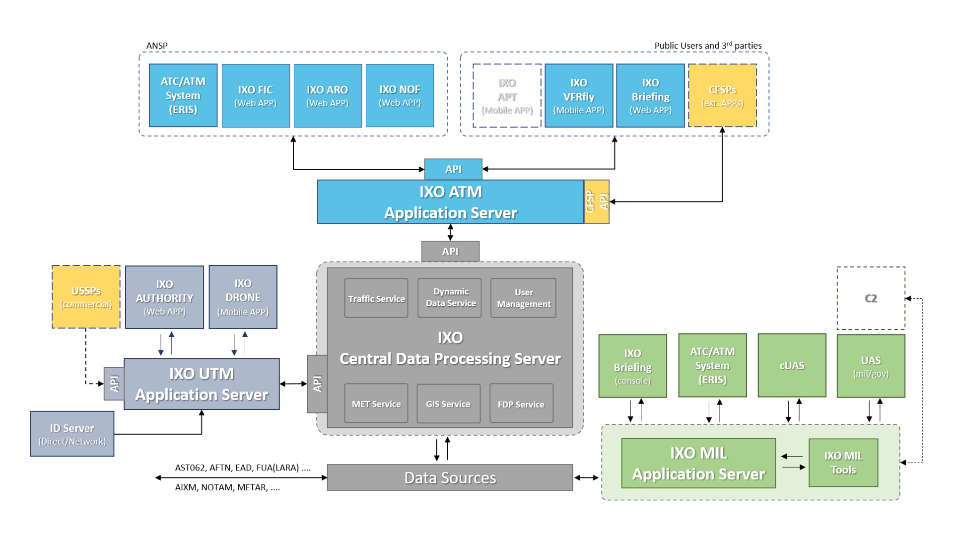
Structure
System features
Description
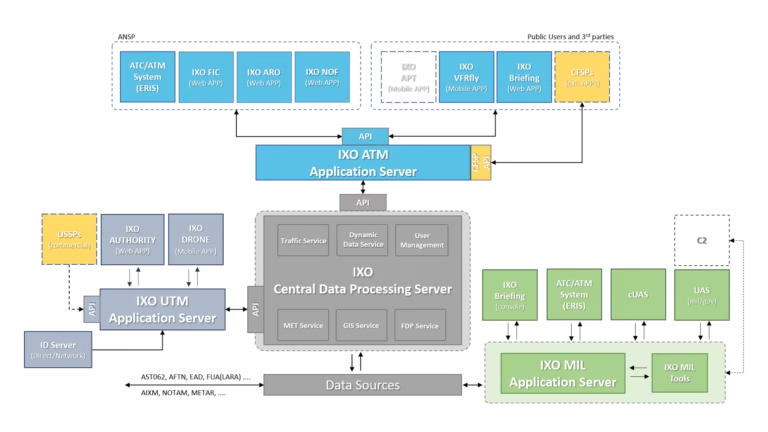
IXO ATM
IXO ATM is a familly of web-based and mobile applications designed for both ANSP operators and Commercial and General Aviation that facilitates overall flight plan management and comprehensive pre-flight planning via state-of-the-art technologies.
Applications
Description
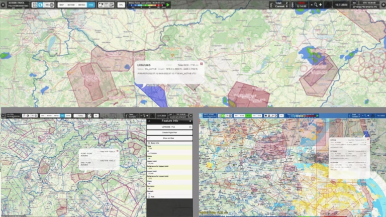
The IXO Briefing application offers interactive flight planning and pre-flight briefing based on valid ANSP and EAD data. IXO Briefing is paperless and accessible from anywhere. Its ability to manage flight plans, and create detailed Pre-flight Information Bulletins in real time provides a significant added value to all its users.
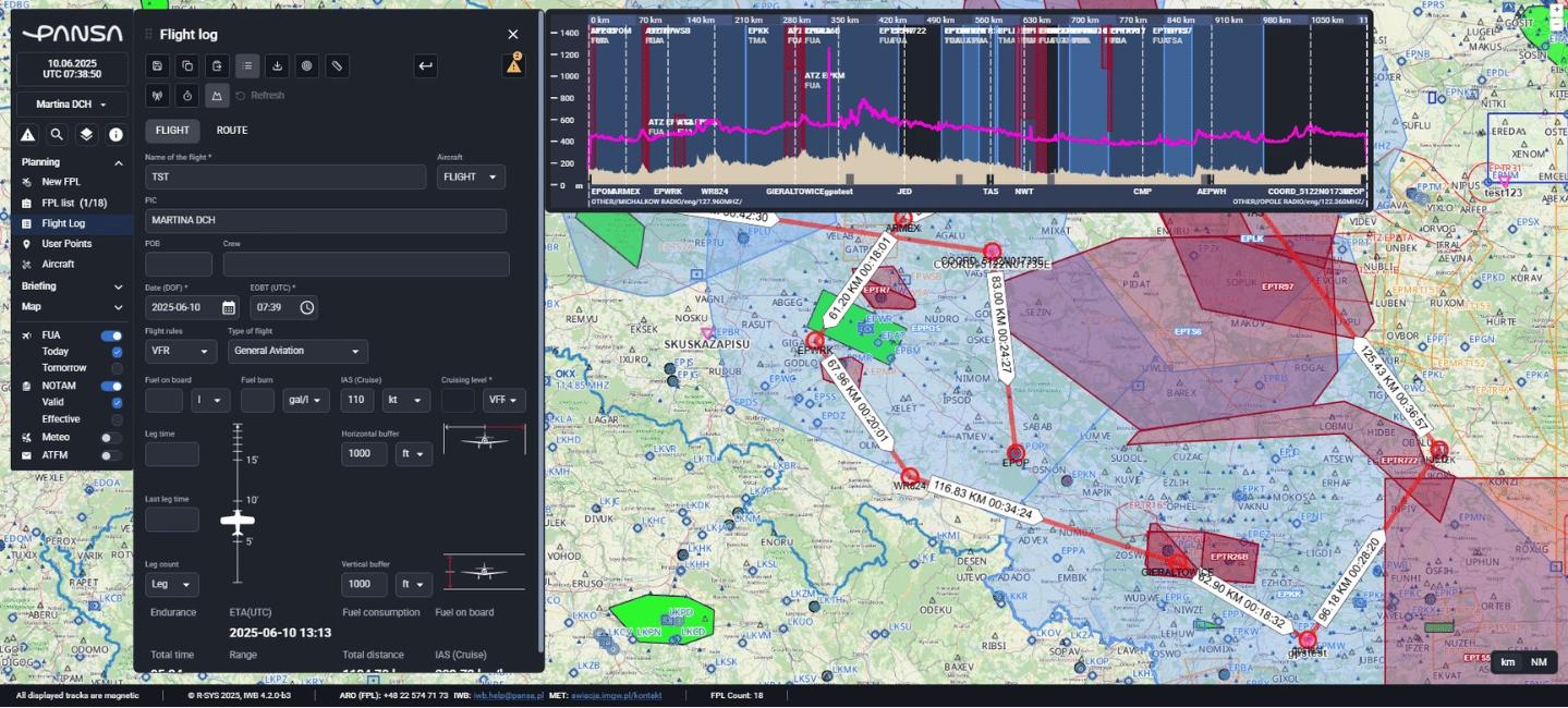
Main features
Interactive flight planning and pre-flight briefing based on valid ANSPs and EAD data
Submission of FPL proposals and FPL-related messages, and their instantaneous updates via dedicated modules
Alerts on potential conflicts of the flight route with terrain, obstacles, static (TRA, TSA, etc.) and dynamic (FUA/LARA) airspace in the flight planning phase
Information on current weather conditions (METAR, satellite and radar images), weather forecast (TAF) and significant weather (SIGMET, lightning, etc.)
2D/3D route visualization
Description
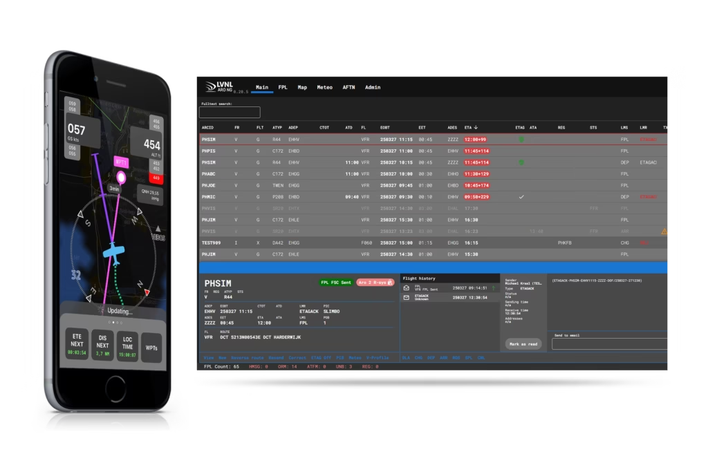
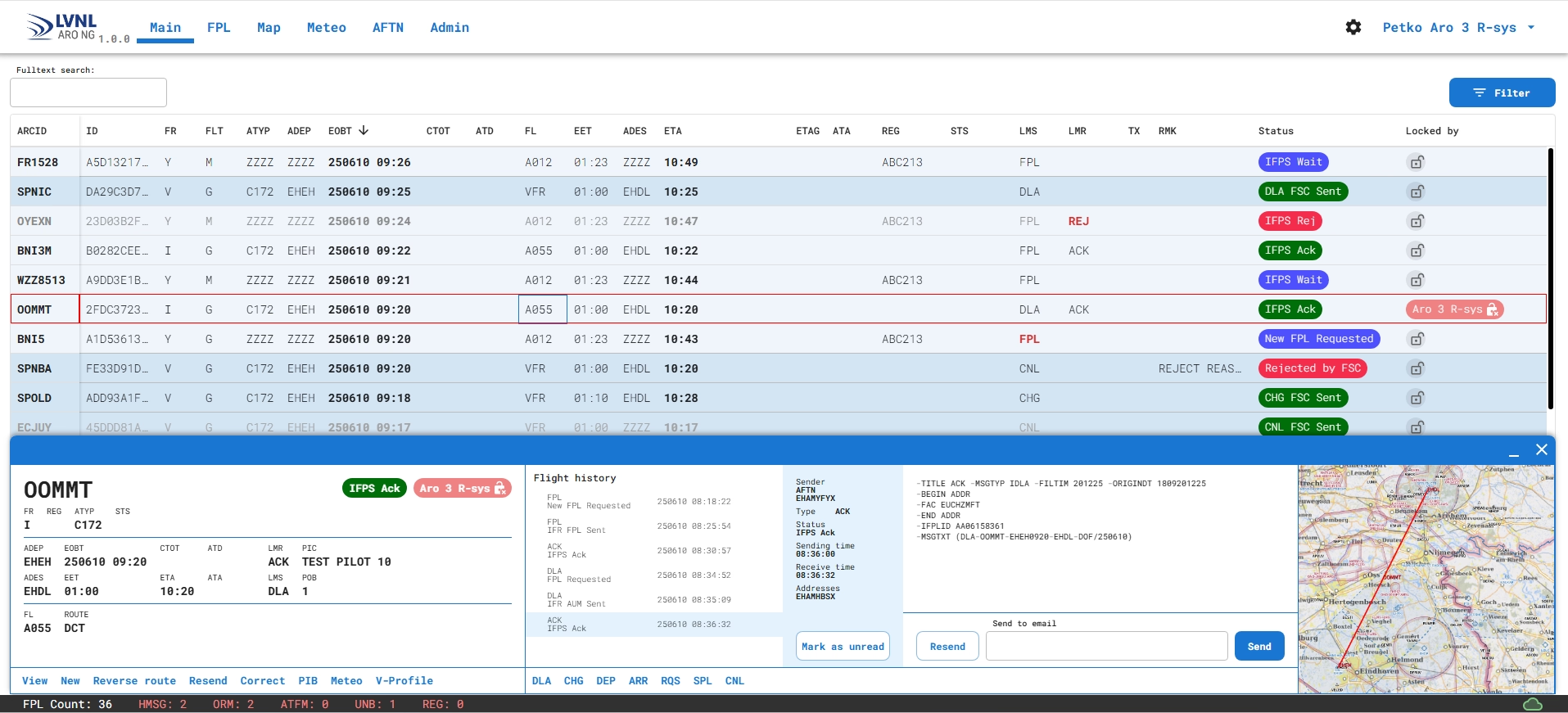
The IXO ARO application is designed specifically for ATS Reporting Office (ARO/CARO) to enable flight plans management in relation with the IXO SYSTEM and its interfaces, and to provide all information and data required for seamless ANSP operations.
IXO ARO is fully compliant with ICAO DOC-4444 (PANS – ATM), ICAO Annex 15 (Aeronautical Information Services), ICAO Annex 3 (Meteorological Service for International Air Navigation), and EUROCONTROL IFPS User Manual, and was developed in close cooperation with several European ANSPs.
Main features
Flight plan management
CFSP API
Access to NOTAM database and other EAD data
Weather information visualization
Aeronautical data display
Interfaces to other AIM tools (e.g. EUROCONTROL Network Manager, AIMSL)
Compliance with the highest cybersecurity requirements according to industry standards
Description
IXO Workstations (consoles) are designed to support the specific needs of ANSPs, aviation authorities, state institutions, municipalities, and airport operators. Each console is individually customized to meet the functional and operational requirements of its respective role, while all consoles operate within a single, centralized data environment.
This architecture ensures unified data management, consistent user experience, and efficient coordination across all operational units.
Main features
Comprehensive management of manned flight operations across all airspace classes
Real-time traffic information and situational awareness to support safe operations
Conformance monitoring to ensure compliance with planned flight trajectories and procedures
Integration with positioning and identification services(including iConspicuity, where applicable)
Flight plan validation and coordination with relevant authorities
Geo-awareness tools, including alerts for airspace structure and activity changes(FUA, eFUA, LARA,…)
Access to up-to-date NOTAM and meteorological information relevant to flight planning and operations
Statistical analysis of operational data and automated reporting for supervisory and safety purposes
Description
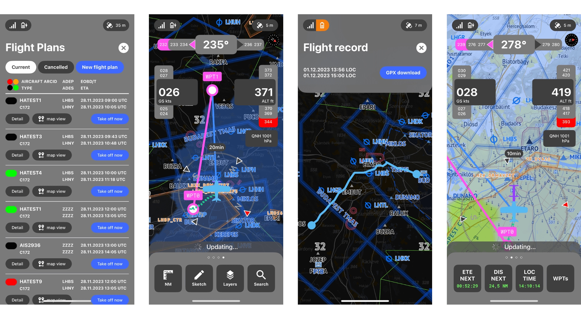
The IXO App is a suite of mobile applications developed for iOS and Android platforms, tailored separately for manned and unmanned aviation.
Each version is specifically designed to meet the unique needs and operational workflows of its target users — whether drone pilots, UAS operators, or general aviation pilots. Despite their distinct functionalities, the apps are part of a shared ecosystem where operational data is securely exchanged to enhance situational awareness, airspace safety, and coordination across different types of airspace users.
Main features
Real-time flight monitoring with full support for electronic conspicuity
Bi-directional integration of traffic information for enhanced situational awareness
Fully automated flight authorization and mission management
Support for FPL-related messages and automatic two-way communication with ANSP/ARO systems
Access to real-time NOTAM and METAR data for pre-flight and in-flight awareness
Mid-air collision prevention with dynamic conflict detection and resolution
Display of surrounding UAS traffic equipped with Direct ID technology
Intuitive, easy-to-use interface tailored for both manned and unmanned aviation
Filing of flight plans (FPLs) directly from the app
Description
The core of IXO System is a virtual platform that provides services covering all requirements of the SWIM-based modular CIS/FIMS platforms, and serves as a digitally centralized single point of truth for all users.
Main features
Real-time flight management and traffic data sharing between ATM and UTM stakeholders
Cross-platform, multi-source data interface (SDO, SDD, AFTN, FUA, AIMSL, NMB2B, XTAM linkage, MET etc.)
Common situational awareness – data for cross-authority and -agency collaborative decision making
Safety Nets – airspace authorization, deconfliction and conflict management
API for provision of valid real-time data for all users (USSPs, C-UAS C2 systems, Security Systems, etc.)
Central airspace management
Description
IXO UTM
Our most recently deployed solution, IXO UTM, built upon the IXO ATM core, is designed for unmanned aircraft operations management. This tool, as a powerful platform for all UTM stakeholders, integrates all information on manned and unmanned aircraft operations, and provides real-time aeronautical data for all airspace users in a common digital environment.
Applications
Description
The IXO Console module, designed for ANSPs, aviation authorities, state institutions, municipalities, and airport operators, allows to manage all UAS operations with a high level of automation thus creating a safe environment for both manned and unmanned traffic and a solid foundation for urban air mobility development.
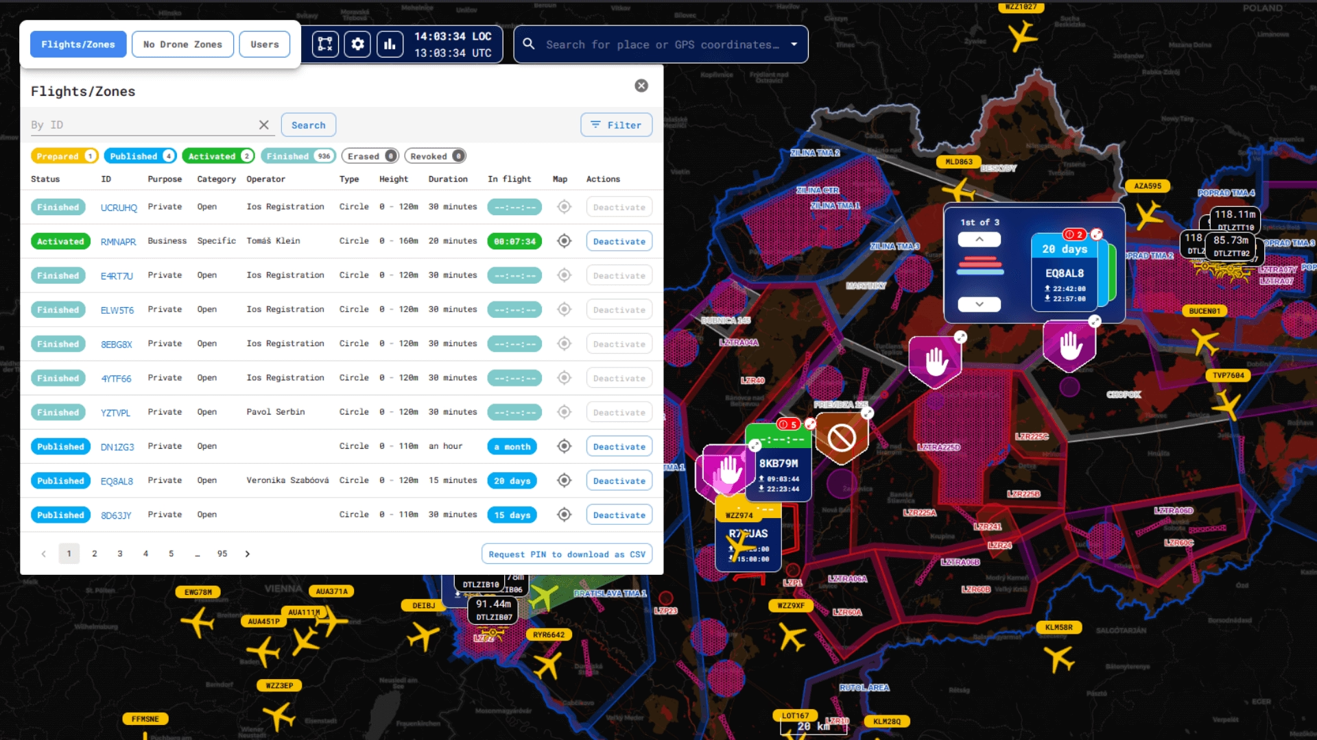
Main features
Management of all levels of UAS operations
Manned and unmanned traffic information and separation
Conformance monitoring service
Remote Network ID and Direct ID service
UAS flight authorization service
Geo-awareness Information on meteorological conditions
Statistical analysis of operational usage data and generation of reports
Description
IXO APP is a mobile application developed for iOS and Android devices intended for drone pilots and UAS operators to facilitate their flight planning.
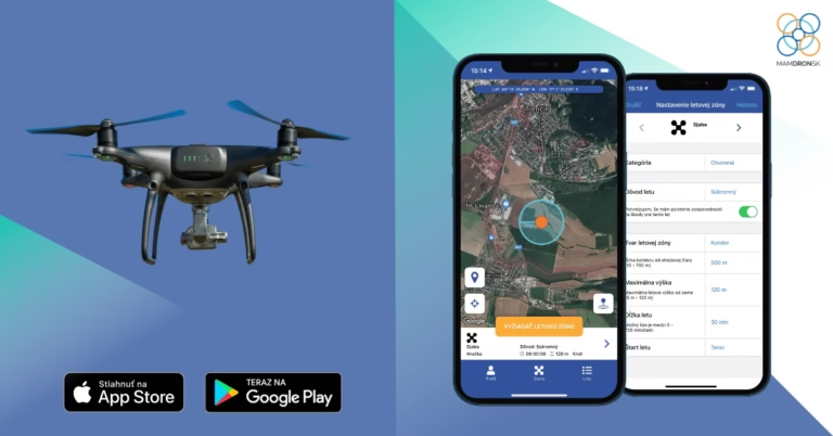
Main features
Real-time flight monitoring
Fully automated flight authorization and management
Mid-air collision prevention and calculations of potential conflicts
Display of other UAS traffic equipped by Direct ID technology
Easy-to-use interface
Description
The core of IXO System is a virtual platform that provides services covering all requirements of the SWIM-based modular CIS/FIMS platforms, and serves as a digitally centralized single point of truth for all users.
Main features
Real-time flight management and traffic data sharing between ATM and UTM stakeholder
Cross-platform, multi-source data interface (SDO, SDD, AFTN, FUA, AIMSL, NMB2B, XTAM linkage, MET etc.)
Common situational awareness – data for cross-authority and -agency collaborative decision making
Safety Nets – airspace authorization, deconfliction and conflict management
API for provision of valid real-time data for all users (USSPs, C-UAS C2 systems, Security Systems, etc.)
Central airspace management
Description
The IXO App is a suite of mobile applications developed for iOS and Android platforms, tailored separately for manned and unmanned aviation.
Each version is specifically designed to meet the unique needs and operational workflows of its target users — whether drone pilots, UAS operators, or general aviation pilots. Despite their distinct functionalities, the apps are part of a shared ecosystem where operational data is securely exchanged to enhance situational awareness, airspace safety, and coordination across different types of airspace users.
Main features
Real-time flight monitoring with full support for electronic conspicuity
Bi-directional integration of traffic information for enhanced situational awareness
Fully automated flight authorization and mission management
Filing of flight plans (FPLs) directly from the app
Support for FPL-related messages and automatic two-way communication with ANSP/ARO systems
Access to real-time NOTAM and METAR data for pre-flight and in-flight awareness
Mid-air collision prevention with dynamic conflict detection and resolution
Display of surrounding UAS traffic equipped with Direct ID technology
Intuitive, easy-to-use interface tailored for both manned and unmanned aviation
Description
The core of IXO System is a virtual platform that provides services covering all requirements of the SWIM-based modular CIS/FIMS platforms, and serves as a digitally centralized single point of truth for all users.
Main features
Real-time flight management and traffic data sharing between ATM and UTM stakeholders
Cross-platform, multi-source data interface (SDO, SDD, AFTN, FUA, AIMSL, NMB2B, XTAM linkage, MET etc.)
Common situational awareness – data for cross-authority and -agency collaborative decision making
Safety Nets – airspace authorization, deconfliction and conflict management
API for provision of valid real-time data for all users (USSPs, C-UAS C2 systems, Security Systems, etc.)
Central airspace management
Description
IXO MIL
IXO MIL solution is specifically tailored for the needs of military, government and law enforcement entities. The system represents the SW solution, which combines advantages of the IXO UTM system, possibility of integration of cUAS elements into the real C2 system.
Applications
Description
The IXO MIL module, designed for military, law enforcement, DCM, and state institutions, allows to manage a broad spectrum of operations, capable of act as a stand alone unit or within the centralized usage – part of a wider command chain in the form of hub between multiple operational layers.
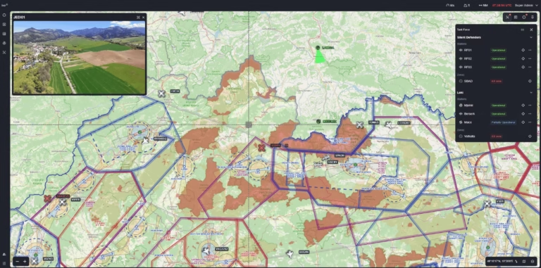
Main features
Management of all levels of UAS operations
Multi sensor real-time data processing
Cooperative and non-cooperative traffic display
Decision-making tools
Conformance monitoring service
Threat Assessment
Task Force creation, display and management
SAPIENT, ACO & JChat implementation
Recordings and statistical analysis